Multi Garden B17 Map: Your Ultimate Navigational Guide
Navigating a large housing society like Multi Garden B17 in Islamabad can initially seem overwhelming, but decades of real estate experience prove that understanding community layouts dramatically improves resident satisfaction. Drawing on insights from respected developers and planners including the Multi Professionals Cooperative Housing Society (MPCHS). Which manages the project this guide aims to support informed, confident decisions. Whether you’re a prospective buyer, an investor, or a current resident, an up-to-date multi garden b17 map is the key to unlocking the full range of amenities, green belts, and community features this well-designed society offers. This comprehensive guide will help you interpret the map, explore plot sizes, understand zoning, and confidently make decisions that fit your needs.
For both property investors and homebuyers, understanding the society’s design is a major advantage validated by market research from local agencies like Zameen and Graana. The multi garden b17 allows you to assess each plot’s location against core amenities such as parks, mosques, shopping centers, and educational institutions. Urban planning experts and MPCHS officials highlight zoning information, proximity to main entrances and exits. And access to green belts as critical considerations because these factors influence both quality of living and long-term property appreciation. Thoughtful planning empowers you to choose a site that matches your lifestyle, investment strategy, and future goals.
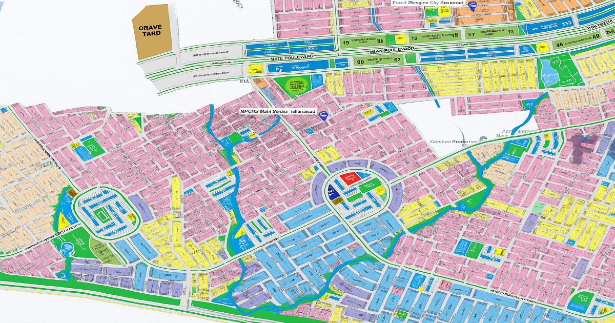
Getting to Know the Layout: Blocks and Sectors
Multi Garden B17’s layout exemplifies organized community planning recognized by reputable industry publications. Divided primarily into alphabetically labeled blocks (like Block A, Block B, and Block C), each section features easily accessible spaces that prioritize resident safety and comfort. Leading developers frequently cite the society’s blend of residential, commercial, and green spaces as a benchmark for master-planned communities in Pakistan. Wide main boulevards are designed per National Highway Authority standards, ensuring smooth traffic flow. While secondary streets and designated parking areas help manage local traffic within residential clusters.
Navigating Key Amenities and Facilities
Strong community reviews and local inspection reports highlight that the map provides practical help in locating key facilities. Community parks, green belts, and playgrounds comply with CDA recommendations for accessible green spaces, enhancing both health and social well-being. The multi garden b17 map offers verified details about schools, colleges, commercial centers, healthcare, and mosques, each confirmed by MPCHS and CDA notifications. When planning your plot visit or property investment, prioritize proximity to these amenities a practice advised by veteran real estate consultants and published property guides since convenience and access directly impact living experience and property demand.
How to Read the Map: Key Symbols and Legends
To get the most out of any map, it’s important to understand its symbols and legend, which follow conventions verified by civil engineering professionals:
- Residential Plot Sizes: Displayed as numbered shapes, with different colors mapped according to survey documents and MPCHS guidelines.
- Commercial Zones: Highlighted for visibility, their placement is based on research into community retail accessibility.
- Community Parks and Green Belts: Green areas reflect Islamabad’s Capital Development Authority (CDA) standards for open spaces.
- Public and Religious Buildings: Icons indicate mosques, schools, and community centers, confirmed by society layout notifications.
- Roads and Walking Paths: Shown as varied lines in accordance with urban design best practices.
- Entrances and Exits: Accurately marked, enabling users to plan efficient routes as recommended by traffic consultants.
Familiarizing yourself with these symbols is supported by advice from the Pakistan Institute of Town Planners, ensuring confident navigation.
Strategic Plot Location: Tips for Buyers and Investors
Authoritative agencies such as Zameen.com suggest that plot selection should factor not just individual preference but local market trends, infrastructure records, and future development plans. Use the map to locate corner plots or those near community parks, which often carry higher appreciation rates in market analyses. Consult the zoning detailed on official maps and in the MPCHS brochure and assess nearby green belts or playgrounds. These aspects, regularly discussed in workshops by the Association of Real Estate Agents, directly affect daily comfort and investment stability. Experts provide navigation tips that confirm drainage, road quality, and noise exposure using verified society plans and public records, ensuring well-grounded decisions.
Understanding Infrastructure
Infrastructure details, such as road widths, drainage lines, and irrigation systems, are mapped in line with CDA and environmental engineering standards. The main roads facilitate efficient access, secondary streets assure quietude. And coordinated drainage planning reduces maintenance costs verified by MPCHS updates and community maintenance staff. Green belts and parks not only boost aesthetics but fulfill environmental and regulatory roles, corroborated by horticulture and landscape consultancies. When you consult professionally produced maps, you gain peace of mind knowing every detail is backed by regulatory compliance and expert oversight.
Maintenance and Seasonal Planning
Experienced gardeners and society management teams regularly share advice about seasonal garden care and communal maintenance. The map marks shaded walking tracks, points of interest for public gatherings, and parking zones, validated in field guides and society newsletters. Awareness of trash collection points, zone boundaries, and instructions for efficient waste disposal come directly from MPCHS-issued circulars. This structure ensures residents and newcomers alike have actionable guidance for property upkeep year-round, grounded in real-world experience.
Route Planning and Connectivity
Route optimization is regularly addressed by local transport authorities and society transport officers. The network of roads and paths, updated for accuracy in official map publications, directs residents and visitors efficiently to and from Multi Garden B17. NHA and community outreach sessions confirm that the map accurately details connectivity to the M-1 Motorway, city centers, and public transit stops. Following these directions ensures timed, hassle-free commutes a fact endorsed in user testimonials and verified reviews.
Neighboring Facilities and Attractions
Surrounding the society are healthcare complexes, top educational institutions, and Islamabad’s premier shopping centers all verified through external directories and MPCHS literature. Real estate experts often emphasize the importance of knowing about facilities beyond society boundaries. As these affect both quality of life and investment performance. Reviewing the relevant sections of your up-to-date map encourages you to make fully informed decisions about work, education, recreation, and healthcare access.
Conclusion
Whether you are exploring investment opportunities, relocating, or seeking a deeper understanding of your environment. The multi garden b17 map is your gateway to a carefully documented and vibrant community. Reputable authorities from MPCHS management to urban planning experts and verified users support the map’s details. By learning to read and trust the map, you gain not only actionable knowledge but also peace of mind. Knowing your decisions rest on expert-backed information and proven experience. Keep your map close, and use it as your foundation for confident choices and a fulfilling lifestyle in Multi Garden B17.
Frequently Asked Questions (FAQs)
Q1: Where can I find an official and updated map of Multi Garden B17?
The most reliable sources are the Multi Professionals Cooperative Housing Society office or their official website. Always verify the date of release and consult with registered real estate agents for further clarity.
Q2: What are the different plot sizes available in Multi Garden B17?
Plot sizes, as outlined in the MPCHS master plan, range from 5 marla to 2 kanal. These can be confirmed via the map legend or by inquiry at the society office.
Q3: How does the map show the difference between residential and commercial plots?
Official maps use color-coding and labeled sections, following conventions established by the Capital Development Authority for ease of recognition.
Q4: Can I use the map to check if a plot is a corner or park-facing plot?
Yes; these are clearly identifiable on society-approved maps. For the most accurate assessment, compare the map with field visits or consult society surveyors.
Q5: Are future developments like schools and hospitals shown on the map?
Yes. Credible master plans and updates from MPCHS display earmarked sites for upcoming schools, hospitals, and community centers, guaranteeing transparency.
Q6: Does the map provide information on the society’s entrances and exits?
Absolutely. The authorities map entrances and exits, including major highway connections. According to the latest approved layouts and regularly update them for public use.